Looking West
Adelaide’s developing road network might be good for motorists, but it could also spark the creation of something truly special for people and nature.
In the third instalment in a series of propositions for rethinking the cities in which ASPECT Studios is based, Tim Conybeare and Peter Phillips explore some ambitious possibilities for Adelaide’s west.

These ideas include reclaiming and relocating sites that hold untapped potential: former industrial spaces in the city’s West could be used to create a network of green public spaces with integrated urban development. Repairing waterways could benefit people and nature in equal measure.
Major infrastructure projects could be capitalised upon, to maximise city shaping opportunities, expand active transport links and create new parks. A more liveable Adelaide is in reach, but only if we are ambitious in our thinking and tireless in our advocacy.
The T2D project, which will tunnel the major north-south transport route beneath the city’s inner western suburbs, presents an unprecedented opportunity to reclaim urban space for regeneration, public use and ecological restoration. By markedly decreasing surface traffic, the project is set to improve air quality and could could foster the creation of green belts that seamlessly connect the urban core to the coast, enhancing mobility and connectivity to natural spaces.


For instance, as industry moves further out from the city, the increasing availability of the previously light industrial lands immediately west of the city offer enormous potential to contribute to housing supply and supporting population growth in line with the Greater Adelaide Regional Plan objective of increasing population density across the city to 46% over the next 30 years.
With these two drivers in mind, we would like to share a vision for the transformation of the city’s west, using a series of tactical urban responses that capitalise on the benefits the completion of the North-South Corridor will bring to the city, while improving the environmental condition, liveability and housing supply across the western suburbs.
An airport that serves the city
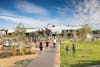
As a catalyst site, let’s look at Adelaide Airport. Occupying an extraordinary 800Ha, around a third of the land between the edge of the western Park Lands to the sea, and the same size as the City of Adelaide within its Park Lands boundary. What if this land were repurposed as a green urban development, enhancing the connection between the city and the sea? Through a relocation of the airport to the existing Parafield airport site, a comparable distance from Adelaide as Heathrow Airport is to central London, we could significantly increase housing availability in the area, potentially accommodating thousands of people based on comparisons with the other successful inner urban regeneration projects in Adelaide, such as the Bowden development. This expansion in housing could help address Adelaide’s growing population needs while ensuring that the development includes substantial open spaces and greening, enhancing the area’s liveability and biodiversity.
The corridors could link existing golf courses to the west, north and south and would create an expansive network of recreational areas that encourage outdoor activities and social interaction. This initiative would further biodiversity and ecological connectivity, creating habitats for local wildlife and promoting environmental stewardship among the community.

Repairing water
Using First Nations led design principles that focus on caring for Country and seeking a deeper connection with land, water and sky, the numerous creeks that run from the hills to the sea could be daylighted and restored – Keswick Creek could be transformed into a linear park with shared path facilities connecting to existing bike networks and an improved green Richmond Road that includes off-road cycle facilities, while the Cowandilla drainage channel (incorporating Water Sensitive Urban Design and stormwater treatment for the broader catchment) would help to increase the urban tree canopy, enhancing the city’s resilience to climate impacts. These measures mitigate urban heat, improve air and water quality, and demonstrate a commitment to environmental stewardship.
Restoring these waterways to a more natural state would improve stormwater management, reduce flood risk, and enhance the area’s ecological health. Creating linear parks along these waterways would provide attractive and functional green spaces for the community, encouraging biodiversity and offering residents access to nature.

Public connections
Introducing a tram spur line down Henley Beach Road to the coast as well as along a re-imagined Richmond Road, through the centre of the Airport site and to West Beach (potentially continuing along the coast south towards Glenelg and linking with the Glenelg tram line to form a loop back to Greenhill Rd) would improve accessibility and connectivity, reducing reliance on private vehicles and contributing to a reduction in traffic congestion and pollution. Tram lines through the area would support denser, transit-oriented development, making it easier for residents to access services, employment, and recreational activities.
Re-zoning Richmond Rd to an Urban Corridor Zone would facilitate medium to high-density residential development along a key transport route, activating the area and providing housing that supports sustainable urban growth. Coupled with enhanced public transport and active transport options, it would create a vibrant, connected community that is attractive to a diverse demographic.

Additionally, there is immense opportunity to redevelop several inner west catalyst sites. Identifying and making use of underperforming land parcels would allow for a thoughtful blend of old and new, celebrating the historical industries that once thrived in these areas. Many of these can be found along the T2D corridor, as well as the edge of the River Torrens, renowned as one of Adelaide’s finest green assets and itself an important parkland link to the city. This approach not only pays homage to the city’s industrial heritage but also provides opportunities for innovative land use that meets current and future needs, such as mixed-use developments, cultural spaces, and green infrastructure.
The re-imagining of Adelaide’s western suburbs can serve as a model for sustainable urban development, balancing growth with environmental preservation, cultural respect, and community well-being. By prioritizing green spaces, enhancing connectivity, and promoting sustainable development, this approach aims to solve problems related to urban sprawl, environmental degradation, and the disconnection of communities from natural assets.

The challenges inherent in such a transformation, such as land acquisition, funding, contamination remediation, and ensuring meaningful engagement with Traditional Owners, require thoughtful planning, collaboration, and a commitment to innovative solutions. Through careful management and a focus on sustainable and inclusive growth, the vision for Adelaide’s western suburbs can be realised, making it a more liveable, resilient, and dynamic part of the city.