Skyrail and the Underline – the maturing of the Caulfield to Dandenong Level Crossing Removal Project

We have arrived at an interesting point in Melbourne’s urban transport history. The Level Crossing Removal Program has matured, the Melbourne Metro Tunnel project is set to open, decisions are being made about an airport train station, and the Suburban Rail Loop is under planning and development.
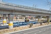
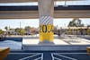
The planned Suburban Rail Loop (SRL) will align with Clayton station, built as part of the Caulfield to Dandenong Level Crossing Removal Project. The proposed SRL will remove and rearrange the existing open space under the viaducts, designed by ASPECT Studios. At this point, we feel it would be useful to return to a post-occupancy analysis we undertook a few years ago, to gauge how the precinct was performing.
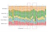
Partnering with Place Intelligence, we conducted a post-occupancy study of how the Underline was used. This involved analysing mobile device location data across 2019 and 2020 from 198,000 unique devices and 20 million signal events to understand how people move through the study area – a swathe of space around Clayton station. We wanted to know how the project was being used. We also wanted an evidence base for future work – by making proposals rooted in data, rather than in suspicion about what might or might not work, we can advance projects that challenge norms. For clients, the study is a demonstration of the project’s impact and proof of a return on a substantial and politically complex investment.


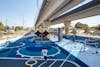
The study shows activity in and around the park soaring, with people flocking not only to the Underline, but also travelling from the new spaces to the surrounding streets and beyond. Active transport corridors – particularly linear ones – are typically transitory spaces that provide meagre opportunity for lingering. They are for moving people. The study reveals that while the Underline does serve that purpose, it has also become something of a destination in its own right. We can observe visitors dwelling in the project’s grassy park, making use of its seating, and treating the park as somewhere worth spending an afternoon. A surprising finding is that people are willing to travel substantial distances to visit the park, with just over half of the visitors travelling more than six kilometres to be there.


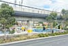
This intensive activation matters. It has all manner of implications for safety, for instance. During the project’s planning phase, an understandable public concern was that the park – situated beneath a railway viaduct – would become home to all manner of unsociable activity. Instead, the Underline hosts intergenerational activity throughout the day, which creates a kind of passive, community-centred surveillance of the space. This environment in turn generates more activity. The spaces become part of the local vernacular, a place to stage daily life, to see people and to be seen.


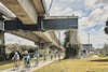
The study highlights how unusual the Underline is, defying typical thinking about what kinds of open spaces can play host to particular types of activation. For one thing, the study tracks a level of activity that, according to convention, should not be taking place on a site this slender and diminutive. For another, it was not co-located with car parking, public toilets, or the kinds of facilities a destination with major play spaces and sports facilities usually would be. Instead, we can observe the way users travel between public transport and activation nodes. This demonstrates how public and active transport connections can be leveraged to provide access – doing away with the need for a major investment in car parking. This is not necessarily a revolutionary idea, but it is a useful point of reference for those interested in reapplying traditional models around a sustainable transport framework.


Everything ASPECT Studios contributed to this project was, in a sense, optional. Bike paths, places to sit and basketball courts did not play a part in achieving the primary goals of relieving congestion on the roads or improving train services. Our thinking was that by committing to the bigger picture parts of the project – using this rare opportunity to look beyond the tracks to improve the surrounding neighbourhoods – it would be possible to achieve something greater for the city. This was a risk, but it was a risk that we can now see was worth taking. Seeing it now still working and bringing joy to the community after 5 years is reward indeed.

CLIENT
Level Crossing Removal Authority, Lend Lease and CPB
TEAM
ASPECT Studios, Cox Architects, Aurecon, WSP, March Studios and John Raynor
TRADITIONAL OWNERS & ONGOING CUSTODIANS OF THE LAND
Bunurong Country
LOCATION
Melbourne, Victoria
YEAR
2015 – 2018